Property Record
3687 Briarcliff Rd Ne, Atlanta, GA 30345
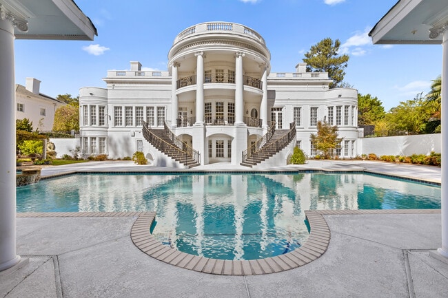

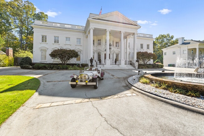
This Property Is For Sale
NEARBY LISTINGS FOR SALE OR LEASE
-
-
View all Atlanta listings for sale on LoopNet.com
Property Detail
3687 Briarcliff Rd Ne
Atlanta-Sandy Springs-Roswell, GA
H G Sheppard
18-194-02-029
DeKalb
Sfr
Georgia
X
1.71 AC
13089C0058K
Briarcliff
14,295 SF
Atlanta
DEMOGRAPHICS near 3687 Briarcliff Rd Ne
1 Mile
3 Mile
5 Mile
2024 Total Population
9,116
103,706
327,780
2029 Population
9,197
104,991
333,794
Pop Growth 2024-2029
+ 0.89%
+ 1.24%
+ 1.83%
Average Age
40
38
38
2024 Total Households
3,599
44,192
142,057
HH Growth 2024-2029
+ 0.89%
+ 1.18%
+ 1.86%
Median Household Inc
$119,241
$102,185
$97,800
Avg Household Size
2.50
2.30
2.20
2024 Avg HH Vehicles
2.00
2.00
2.00
Median Home Value
$691,949
$504,549
$493,594
Median Year Built
1970
1978
1984
Nearby Places
- Restaurants
- Banks
- Shops
- Fitness
- Groceries
PUBLIC TRANSPORTATION
COMMUTER RAIL
Atlanta (Crescent - Amtrak)
DRIVE
WALK
Distance
Atlanta (Crescent - Amtrak)
12 min
7.4 mi
AIRPORT
Hartsfield - Jackson Atlanta International
DRIVE
WALK
Distance
Hartsfield - Jackson Atlanta International
30 min
20.2 mi
Freight Ports
Georgia Ports - Savannah
DRIVE
WALK
Distance
Georgia Ports - Savannah
291 min
258.1 mi
Nearby Properties
Address
Land Use
TOTAL SIZE
Lot Size
Zoning
Address
Land Use
TOTAL SIZE
Lot Size
Zoning
12,600 SF
508.30 AC
M
Address
Land Use
TOTAL SIZE
Lot Size
Zoning
169,435 SF
76.18 AC
M
Address
Land Use
TOTAL SIZE
Lot Size
Zoning
431,259 SF
48.90 AC
RM100
Address
Land Use
TOTAL SIZE
Lot Size
Zoning
187,172 SF
7.22 AC
OI
Address
Land Use
TOTAL SIZE
Lot Size
Zoning
257,989 SF
12.41 AC
OI
Address
Land Use
TOTAL SIZE
Lot Size
Zoning
131,793 SF
4.30 AC
X
Address
Land Use
TOTAL SIZE
Lot Size
Zoning
307,824 SF
16.40 AC
X
Address
Land Use
TOTAL SIZE
Lot Size
Zoning
729,294 SF
0.01 AC
X
Address
Land Use
TOTAL SIZE
Lot Size
Zoning
321,334 SF
12.70 AC
RM-HD
Address
Land Use
TOTAL SIZE
Lot Size
Zoning
150,894 SF
3.85 AC
C2
Address
Land Use
TOTAL SIZE
Lot Size
Zoning
457,330 SF
20.49 AC
RM-HD
Address
Land Use
TOTAL SIZE
Lot Size
Zoning
345,441 SF
25.78 AC
C1
Address
Land Use
TOTAL SIZE
Lot Size
Zoning
194,350 SF
4.68 AC
OCR
Address
Land Use
TOTAL SIZE
Lot Size
Zoning
377,506 SF
8.70 AC
X
Address
Land Use
TOTAL SIZE
Lot Size
Zoning
165,458 SF
4.80 AC
R85
Address
Land Use
TOTAL SIZE
Lot Size
Zoning
267,983 SF
13 AC
X
Address
Land Use
TOTAL SIZE
Lot Size
Zoning
325,232 SF
23.10 AC
X
Address
Land Use
TOTAL SIZE
Lot Size
Zoning
357,531 SF
11.51 AC
RM75
Address
Land Use
TOTAL SIZE
Lot Size
Zoning
208,608 SF
20.89 AC
OI: OFFICE
Address
Land Use
TOTAL SIZE
Lot Size
Zoning
360,321 SF
24.90 AC
RM85
Address
Land Use
TOTAL SIZE
Lot Size
Zoning
435,463 SF
36.78 AC
X
Address
Land Use
TOTAL SIZE
Lot Size
Zoning
336,012 SF
6.70 AC
OI
Address
Land Use
TOTAL SIZE
Lot Size
Zoning
95,048 SF
3.12 AC
OI
Address
Land Use
TOTAL SIZE
Lot Size
Zoning
228,504 SF
15.57 AC
M
Address
Land Use
TOTAL SIZE
Lot Size
Zoning
166,663 SF
8.65 AC
X
Address
Land Use
TOTAL SIZE
Lot Size
Zoning
338,478 SF
12.27 AC
OI
Address
Land Use
TOTAL SIZE
Lot Size
Zoning
259,834 SF
3.56 AC
OI
Address
Land Use
TOTAL SIZE
Lot Size
Zoning
70,929 SF
6.64 AC
C1: LOCAL
Address
Land Use
TOTAL SIZE
Lot Size
Zoning
296,175 SF
18.95 AC
RM100
Address
Land Use
TOTAL SIZE
Lot Size
Zoning
355,421 SF
7.03 AC
X
The World's #1 Commercial Real Estate Marketplace
Connect with us
© 2025 CoStar Group
The information above has been obtained from sources believed reliable. While we do not doubt its accuracy we have not verified it and make no guarantee, warranty or representation about it. It is your responsibility to independently confirm its accuracy and completeness. Any projections, opinions, assumptions, or estimates used are for example only and do not represent the current or future performance of the property. The value of this transaction to you depends on tax and other factors which should be evaluated by your tax, financial, and legal advisors. You and your advisors should conduct a careful, independent investigation of the property to determine to your satisfaction the suitability of the property for your needs.